


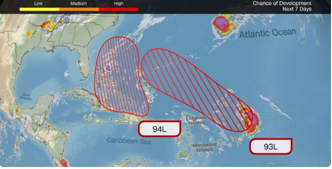
Two areas of disturbed weather in the Atlantic — Invest 94L and Invest 93L — have a growing chance of developing into tropical cyclones this week as the hurricane season’s late-stage hot spots shift closer to land.
Invest 94L
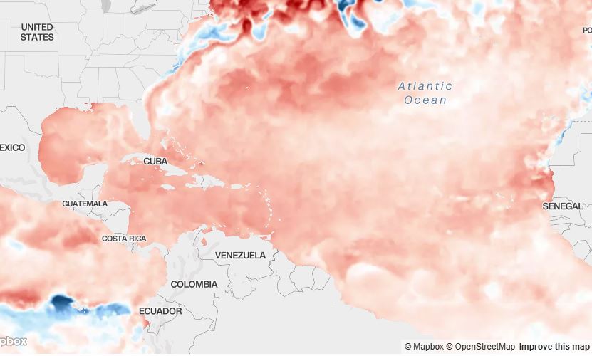
Centered near the northeastern Caribbean, Invest 94L is producing disorganized showers and thunderstorms. It could strengthen into a tropical depression or tropical storm as it nears the Bahamas and the U.S. Southeast later this week. Forecasters say the odds of development are high, though there is still uncertainty about how well it will organize. Favorable upper-air conditions and unusually warm ocean waters give it fuel to intensify, but it could also stay offshore or take a path between Bermuda and the U.S. coast — outcomes seen earlier this season.
Invest 93L
To the east, Invest 93L is showing signs of organization and may become a tropical depression or storm by the weekend. Its projected track could bring it closer to Bermuda than Hurricane Gabrielle did, and it has the potential to strengthen into a hurricane. At this stage, a direct U.S. impact appears unlikely.
What an “Invest” Means
An “invest” is simply a label the National Hurricane Center uses to mark an area of interest for further analysis. Once a system is tagged, it receives dedicated satellite monitoring and computer-model runs to help forecasters predict its future track and intensity.
Impacts and Forecast Challenges
- Invest 94L could bring heavy, flooding rain to Puerto Rico and the U.S. and British Virgin Islands through midweek, with isolated totals up to 6 inches possible. This raises the risk of flash flooding and landslides in steep terrain. Residents of the Bahamas and the U.S. Southeast should stay updated as forecasts become more certain.
- Predicting the paths of 93L and 94L is challenging because a dipping jet stream over the Eastern U.S. could steer them in different directions. If the two disturbances drift close to one another, they may interact — tugging or rotating around each other — complicating forecasts further.
South Asian Community Advisory
The recent flooding in Puerto Rico, the Virgin Islands, and the U.S. Southeast severely impacted many in the South Asian community, including Pakistani, Indian, and Bangladeshi families who live and work in these regions. Homes and businesses were affected, highlighting the vulnerability of immigrant communities during extreme weather events. Officials urge all residents, especially South Asians, to closely monitor National Hurricane Center alerts, follow local emergency instructions, and be prepared to move to safer locations if necessary.
Seasonal Context
As October approaches, late-season storm formation shifts westward toward the Gulf of Mexico, Caribbean, and western Atlantic, which lie closer to land and increase the risk of hazardous impacts. Through Sept. 22, 2025, the Atlantic has produced seven named storms — below the long-term average of 10 by this date — and only two have become hurricanes (Erin and Gabrielle). Still, those that formed were unusually intense, with Erin reaching Category 5 and Gabrielle Category 4. Historically, October and November bring four more named storms on average, but late-season activity can vary widely.

It is too early to determine where the 2025 season will ultimately land, but warm waters near land increase the risk of late-season storms. Communities in Puerto Rico, the Virgin Islands, the Bahamas, Bermuda, and the U.S. Southeast — including the South Asian diaspora — should stay alert, follow official forecasts, and be prepared for potential impacts.

