


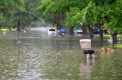
HOUSTON, Texas — October 13, 2026 — Houston residents are experiencing another warm, humid day as moisture flowing inland from the Gulf of Mexico increases the potential for showers and thunderstorms across Southeast Texas. While the muggy conditions may feel uncomfortable, they also highlight an important weather-readiness concern: how quickly heavy rainfall can create hazardous conditions on Houston-area roads.
The National Weather Service (NWS) Houston/Galveston office describes Tuesday’s weather as warm and muggy, with afternoon showers and thunderstorms possible. Temperatures are expected to reach around 90 degrees Fahrenheit (32°C), with scattered rainfall potentially affecting afternoon travel. Brief, heavy downpours could cause temporary flooding on roads and in areas with poor drainage.
Why does the air feel so humid?
The explanation lies partly in a weather measurement known as precipitable water (PW). It estimates how much water vapour is present in a column of the atmosphere, expressed as the depth of water that would result if all that vapour condensed.
When PW values are high, the atmosphere contains abundant moisture that can contribute to heavy rainfall if showers or thunderstorms develop. Persistent onshore winds carry warm, moisture-rich air from the Gulf inland, helping create the sticky conditions familiar to Houston residents.
However, high PW does not automatically mean flooding will occur. The amount of rain that falls, how long a storm remains over one location, and the capacity of local drainage systems all influence the actual risk.
What does this mean for Houston residents?
The immediate concern is localized rather than necessarily widespread flooding. Intense rainfall can overwhelm storm drains, collect at underpasses and low-lying intersections, and create dangerous driving conditions, even when the storm lasts only a short time.

Motorists should allow extra travel time, check weather radar before leaving and avoid roads where water is accumulating. Never drive through floodwater: its depth can be difficult to judge, and moving water can sweep vehicles off the road.
Residents should also monitor official weather alerts, particularly if thunderstorms develop near their neighbourhoods. Anyone living in a flood-prone area should know alternative routes and identify a safer location in case conditions deteriorate.
Humidity presents a separate health concern. High moisture levels make it harder for sweat to evaporate, reducing the body’s ability to cool itself. Drinking water regularly, taking breaks in air-conditioned spaces and limiting strenuous outdoor activity during the hottest hours can help reduce the risk of heat-related illness.
What comes next?
The forecast points to continued warm conditions and scattered showers into midweek, followed by a potential change in the weather as a cold front approaches Friday. Cooler, drier conditions are expected behind the front, although residents should check updated forecasts for timing and local impacts.
For real-time updates, consult the National Weather Service Houston/Galveston and the Harris County Flood Control District.
For Houston families, preparedness starts before water reaches the street. Checking alerts, planning safe routes and understanding local flood risks can make a meaningful difference when the next downpour arrives.
Pulse News | Stay informed. Stay prepared.

